
Mt Bartle Frere (1622m) is the tallest mountain in Queensland. The summit track is primarily a walk with little scrambling on offer


Rob gains the eastern summit and the highest point in Queensland (1622m)

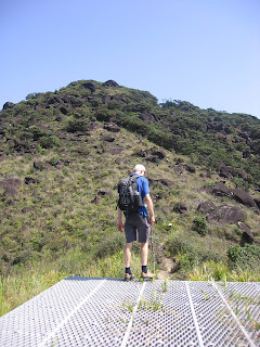
Rod seeking a view near the summit sign

 Upon return to the car park, Josephine Falls provides an excellent place to relax and soak some weary muscles.
DESCRIPTION:
The Mount Bartle Frere summit is the highest peak in Queensland (1622m) and located within the Wooroonooran National Park approximately 75km south of Cairns in North Queensland. The summit trail passes over the mountain in an east - west direction and a car shuffle would be required to complete this 15km walk. The most common summit route is a 15km return hike from the eastern side of the mountain commencing and concluding at the Josephine Falls Car Park. Both sides of the mountain are accessible by conventional vehicle, however a 4WD is required to reach the upper end of Gourka Road (to Junction Camp) on the western side.
Some track notes refer to camping either at Big Rock Camp, Broken Nose or the Eastern Summit Camp (helipad and evacuation hut). In our experience this is not necessary in good weather as completing both hikes either from east to west (Josephine Falls to Junction Camp) or the eastern return (starting and concluding at Josephine Falls) are quite achievable in 9 - 10 hours for those of above average fitness levels. Camping permits can be obtained on-line from www.qld.gov.au/camping or by Telephone: 13 13 04.
The average yearly rainfall regularly reaches four metres on the mountain and therefore sudden weather changes are normal in this region and must be considered in your preparation. The dry season (which is really the drier season) runs from April - September and is the recommended time for this hike.
See the Queensland Government Parks and Wildlife site for further information:
http://www.epa.qld.gov.au/parks_and_forests/find_a_park_or_forest/bartle_frere_trail_wooroonooran_national_park/
http://www.epa.qld.gov.au/parks_and_forests/find_a_park_or_forest/bartle_frere_trail_wooroonooran_national_park/
LOCATION:
The Bartle Frere trail can be accessed by road from the coast at Josephine Falls Car Park or from the west via the Atherton Tableland.
To access Josephine Falls from Cairns travel south on the Bruce Highway for 65km to Miriwinni. 2km south of Miriwinni turn right off the Bruce Highway onto Bartle Frere Road and proceed 8km to Josephine Falls. Access is by conventional vehicle.
To access to the western trail from Cairns travel south on the Bruce highway for 21km to Gordonvale. Turn right on the Gordonvale - Atherton Road (Gillies Highway) and proceed 38km to left turn into Wrights Creek Road. Follow for 6km through Lake Eacham looking for left turn into Topaz Road approximately 2-3km past Lake Eacham. Proceed on Topaz Road for 2km past Butchers Creek School taking left turn to Lamins Hill Lookout on Old Cairns Track which is a gravel road. Proceed for 300 metres turning left at the T junction (still on Old Cairns Track) and take the next turn right into Gourka Road.
Follow Gourka Road with care for 7km to the start of the Wooroonooran National Park boundary. Conventional vehicles should not proceed past this point. If visiting in the wet season, check road conditions beyond the park boundary by contacting the EPA as the road may be closed or suitable for 4WD vehicles only. 4WD vehicles may continue a further 2km to Junction Camp and the official start of the Western Track. The start of the Western Track is considerably higher (approximately 700 metre altitude) than the start of the eastern Josephine Falls Track (approximately 100 metres).
For information on the condition of Gourka Road, basic map, bushwalking registration contact the EPA: Web: http://www.epa.qld.gov.au/projects/park/index.cgi?parkid=125
TRAIL NOTES:
The notes below refer to the 15km Josephine Falls return track. We did not attempt the Western Trail due to having only one vehicle available and one day to complete the walk.
As indicated through our blog preparation is critical for all hiking, and especially on Mt Bartle Frere. The challenge comes mainly in two forms; 1. the unrelenting 3.5km section from Big Rock Camp to the Eastern Summit Camp & 2. variable weather conditions in the form of heavy rainfall, reduced visibility from cloud and sudden temperature fluctuations.
The EPA advise the Josephine Falls trek is extremely demanding and should only be undertaken by experienced bushwalkers. They also recommended allowing two days for the ascent to the summit and back to either the east (Josephine Falls) or the west (Tablelands). We consider ourselves to be of average fitness* and were able to complete the walk in about 9 hours and enjoy a refreshing mid afternoon swim at Josephine Falls. (*based on a pace of 8 hours for the 16.5km South East Ridge - South Ridge circuit on Mt Barney which is fairly average).
The key is to get an early start.
Josephine Falls Track
Register at the information hut at the start of the walk (100m altitude) near the Josephine Falls Car Park and proceed on the wide track to Majuba Creek through the lowland rainforest. This first section should take approximately 1 hour and is a common first rest spot. Water can be refilled here if required.
From Majuba Creek the track narrows and becomes more steep and root bound as it winds gradually up to Big Rock Campsite. As scramblers (and occasional free climbers) we don't really get the attraction of camping at Big Rock as all the hard work is yet to come. There are also multiple nightmare tales from unsuspecting campers in this areas (usually in relation to bush rats and leeches) which is more reasons not to stop for the night.
From Big Rock a popular detour for campers is the lookout of Broken Nose (962m). We did not attempt this as we were pushing for the summit, however the option is there. This first section from the car park to Big Rock is relatively flat and only gains 400 metres over 3.5km.
Just above the Big Rock Campsite, Majuba Creek crosses the track for the last time providing another easy water access point. From here the track starts to increase considerably in gradient over the 3.5km to the Eastern Summit Camp (helipad and evacuation hut). 1 km orange markers can be seen along this section however were becoming dull due with weathering.
This section is really the grind of the hike, especially in wet weather, as it gains 1000 + metres in elevation in a distance of approximately 3.5km (about 28 degrees). The vegetation begins to thin in this section as you leave the rainforest floor, ascend through the foothills and on into the upland forest area of the Helipad & Evac Hut (approx. 14oom). Supplies in the Hut are for emergency purposes only and should not be raided simply because they are there. Consider making a deposit rather than a withdrawal.
From the Helipad follow the clear footpad through the boulder field and past a couple of false summits and up a final short push to the summit area. Exposure to elevation is not an issue on Bartle Frere as the track does not pass near any drop offs, however care does need to be taken in the boulder field especially in wet weather.
As the summit area is shrouded by shrubs, over the years hikers have scrambled 4-5 metres up a nearby tree in the hope of improving the outlook. As the tree has now been dead for years it is not recommend to climb it. On a clear day spectacular views are available to the Barrier Reef, Innisfail and the inland Tablelands. From the summit retrace your steps to Josephine Falls or continue on to the west.
PROVISIONS:
To Wear:
* Hat
* Sunnies (optional)
* Good quality walking / running / hiking shoes in good condition.
Hiking Pack: 45 - 50 litres is an ideal sized day-pack for Bartle Frere.
When camping include the basic listed below plus tent, ground sheet, sleeping mat, light sleeping bag and excellent repellent. Do not plan to carry anything in your hands.
To Carry in Hiking Pack:
*Topographic map & Compass
* 3L Water (minimum or more if you drink a lot). Consider packing some powdered electrolyte to stave off cramp.
* Food for snacks and lunch on the summit (consider packing more than you need for 1 day):
- Sizeable lunch of sandwiches / pasta / etc
- Muesli bars- Fruit (fresh or dried)
- Chocolate
- Salt (tasty with lunch and for leech removal)
* Basic First Aid Kit including:
- Sunscreen
- Insect repellent
- Bandaids
- Pressure bandage
- Elastic ankle support
- Paracetamol
- Personal medications
- Basic first aid book
* Mobile Phone (fully charged)
* Quality wet weather gear:
- Spray jacket with hood
* Cold weather gear:
- Space blanket
- Jacket
- Long trousers
- Beanie (head warmer)
- Gloves- Flint or Matches (waterproof) in case of emergency
* Head lamp and Batteries* Shovel and toilet paper
* Gaiters
Optional Equipment:
* Camera & Batteries
* GPS
* Change of shirt / clothes for the return car ride (to leave in the car)
HISTORY:
Without seeking to reinvent the wheel the following site contains some excellent information:
Bartle Frere forms part of the traditional lands of the Noongyanbudda Ngadjon people who refer to it as Chooreechillum. They have lived in this area for thousands of years and believed when they die their spirits were reborn to continue to watch over the people and the region.
In 1873 Europeans named the mountain after Sir Henry Bartle Frere (the British Governor of Cape Colony during the Zulu Wars and President of the Royal Geographical Society). The first recorded European to summit was Christie Palmerston in 1886, assisted by Noongyanbudda Ngadjon men.
Bartle Frere's immediate neighbour is Mt Bellenden Ker the second highest mountain in Queensland at 1,611 metres. In 1942 an American B-25 Mitchell medium range bomber crashed on the mountain with the loss of all seven crew members.
The eastern approach from Josephine Falls follows a rough track used in the 1890s by tin miners who worked a mining claim near the summit. Parts of the trail from the Atherton Tableland follow traditional Aboriginal walking tracks.
No comments:
Post a Comment