Sunday, November 29, 2009

Spicers Peak, Clumber, South East Queensland

From the carpark follow the signs and clear walking track 150m to Governors Chair Lookout


A plaque indicates other minor peaks in the Frassifern Valley


Mt Granville and Moon with 'The Governors Chair' rock formation prominent in the foreground


The two peaks of Mt Barney from Governors Chair (approximately 25km to the south east)


Spicers Peak is clearly visible to the South from the carpark and Governors Chair


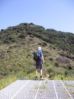
Jim beginning to gain some elevation about half way up the North East Ridge


Grasstrees on the upper section of the North East Ridge


Direct access to the summit via the top of the North East Ridge is very steep and easiest access is gained by skirting west (right) at the base of the summit ridge to ascend through the forest


Section of the forest track which provides access to the summit


Upper section of the Eastern Face of Spicers Peak


Summit cairn at 1222 metres


Looking east to Frassifern Valley from a small clearing beside the summit cairn


Summit views are hindered by thick vegetation


A glimpse of the Barney peaks from the summit through thick vegetation.

DESCRIPTION:


Spicers Peak is the most northerly of a series of steep peaks and ridges in the Main Range National Park and is now a World Heritage listed area. In the early 1820s it was becoming increasingly necessary to find a route between the colony of Moreton Bay and the rich farming lands of the Darling Downs. In 1828 Allan Cunningham was credited as the first European to find a route through the pass of Cunningham's Gap, however surveying teams deemed conditions to be too steep for a road.


In 1847 an alternative route was identified by stockman Henry Alphen to the south of Cunninghams Gap. It is thought Aboriginees were using this section of the range as a trade route between the east and west. Alan Cunningham had noted this 'gap' some 20 years earlier but had not deemed it unsuitable for transport. Cunningham named Spicer's Gap after Peter Spicer, Superintendent of convicts a Moreton Bay as he had originally identified Spicers Peak while searching for escaped convicts.


In the mid 1860's, Spicer's Gap became the first safe and trafficable route between the coast and the Darling Downs. In 1927 improvements in engineering allowed a more direct route to be constructed through the originally proposed route of Cunningham's Gap. This road was sealed in 1940 and is now known as the Cunninghay Highway which runs from Ipswich to Goondiwindi via Warwick.


The summit walk starts from the Govervors Chair Carpark at the end of Spicers Gap Road. Spicers Peak is visible to the south from the carpark and nearby Governors Chair Lookout. Check local weather forecasts and conditions before setting out at www.weatherzone.com.au/ or http://mirror.bom.gov.au/weather/radar/. The approach footpad is comprised of compacted earth however the ridgeline contains a lot of loose dirt and leaf litter, which would turn Spicers Peak into a frustrating scramble during wet weather.


The hiker's track (See Track Notes below) is not exposed however care is required in some sections especially during descent. The summit area contains thick vegetation which greatly hinders views to the Frassifern Valley and south west to Mt Barney. Some guidebooks recommend allowing 6 hours + to complete the 6km return walk however this can be halved if you walk up and down with just a couple of drink breaks.


LOCATION:


From Brisbane proceed west along Ipswich Road taking the turnoff south toward Warwick on the Cunningham Highway. Approximately 5 km past Aratula (located 60km south of Ipswich) turn into Lake Moogerah Road on the left. Proceed for 5.8 km and turn right into Spicers Gap Road. After 3km the road becomes gravel and recommended for dry use only. Continue winding slowly (average 30km/h) for the next 6km past Spicers Gap campground (4km) and the last toilet facility to the Governors Chair Carpark (end of road).


In the carpark take the western track marked 'Governors Chair Lookout.' On a clear day Spicers Peak should be visible from the carpark and lookout. As for all hikes in the bush adequate preparation and equipment should be attended to. If in any doubt about proper etiquette check notes under 'Bushwalking Ethics.'


TRACK NOTES:


As indicated under 'Description' the summit track is clearly marked from the carpark. Follow the track to Governors Chair Lookout (150 metres) for great views of the Frassifern Valley below. The old Governor actually had the right idea by soaking in the views from here and not going any further. The next 3km don't really offer any better vantage points to the east than what is on offer from the lookout. Nevertheless the summit walk is of some interest for the views to the north, a nice little section of ridgeline below the summit and the possibility of some moody photos on an overcast day. The weather patterns in the Scenic Rim will usually always be different from Brisbane and it is often work the drive even to escape the coastal humidity for a few hours.


From the Governors Chair walk south toward the visible Peak to fenceline running north - south. The approach track follows close the fenceline with the occasional deviation around fallen trees or through low scrub. Seasonal low grass (up to 50cm) covers much of the footpad from Governors Chair to a clearing offering pleasant views of the valley. If you loose the track anywhere along this section keep veering back toward the fence on your left hand side (east).


From the clearing the fence ends and the footpad becomes more clearly definable. It is really just a matter of following it to the summit. As the north east ridgeline gains altitude the track becomes subject to erosion with plentiful loose dirt and small rocks scattered over its surface. The original track was apparently precariously close to the eastern face however a well worn track skirts a safe distance (for the most part) from any sheer drops. Numbers of deviations become evident when ever the track flattens out however 'all roads lead to roam' providing they are not far from the ridgeline and of the north east course.


A couple of minor cliffs great you along the ridgeline which may be negotiated by short sections of scrambling or free climbing, depending upon individual skills. A rope should not be necessary unless rock climbing is intended, however it is always wise to carry a short length for assistance during inclement weather or for inexperienced scramblers.


Approximately 50 metres from the base of the summit cliffs a track veers off to the right (west) to assist walkers through a short forest section to the thickly vegetated summit. Walking up to the base of the cliffs reveals another track which also continues west to join with the lower track before the forest section. The obvious track leads 80 metres up through the forest to a three way junction. Take the left hand (northern) track 40 metres to the small, dense summit area marked by a significant and overgrown rock cairn.


Some track notes suggest a circuit route via the North West Ridge however the thickness of the bush, difficulty of track recognition and distance from the carpark would discourage all but the most intrepid from such a venture. Other track notes are available at: http://www.southee.com/Bushwalking/MainRange.html#label031.


We descended with care via the same approach route in just over 3 hours. Arrival at Aratula for coffee and cake revealed a number of passengers in the form of bush ticks which had decided to migrate from rural to urban life via us. Few lived to tell the tale to their grandkids.


PROVISIONS:


To Wear:


* Hat


* Sunnies (optional)


* Good quality walking or running shoes in good condition.


Hiking Pack:* 30 – 45 litres is an ideal sized day-pack.


Do not plan to carry anything in your hands.


To Carry in Hiking Pack:


* 2L Water (minimum or more if you drink a lot).


* Food (for a snack on the summit):


- Muesli bars


- Fruit (fresh or dried)


- Chocolate


* Basic First Aid Kit including:


- Sunscreen


- Insect repellent


- Tweezers (ticks can be thick in this area, especially in summer)


- Bandaids


- Pressure bandage


- Paracetamol


- Personal medications


* Mobile Phone (fully charged)


* Camera & Batteries


Optional Equipment:
* 20 - 30 metres of rope is recommended in case of rain or anxiety


* Change of shirt / clothes for the return car ride (to leave in the car)


* Wet weather gear:


- Spray jacket


- Gloves


* Head light and Batteries


HISTORY:


According to the EPA website the forests of the Great Dividing Range were logged extensively from the mid 1800's to the early 1900s. Cunningham's Gap was reserved as a national park in 1909 and walking tracks were built from the late 1930s to the late 1950s. In the 1960s and 1970s, a number of other national parks were reserved along the Main Range. In August 1980, the parks were amalgamated to form Main Range National Park. More information can be found at:


main_range_national_park/main_range_national_park__nature_culture_and_history.html


The original Spicers Gap Road was used by the general public up until the 1990's and joins the Cunningham Highway just east of Tregony. It still appears on Google Maps but good luck getting through there in your Barina.


Sunday, October 18, 2009

Hinchinbrook Island - North Queensland

Northern Ferry preparing to leave Port Hinchinbrook for the 2 hour trip to the island.


Caleb and Jim on the top deck of the ferry with aluminium dinghy following.


Nina Peak on the left (312m) with minor peaks below Mt Bowen (1121m) with looms further to the west.

Transferring hikers to the dinghy to enable entry to the drop off point.

A raised boardwalk through mangroves provides access to Ramsay Bay on the eastern side of the island.
All beaches on the eastern side of the island are broad with very flat waves.

Looking north to Blacksand Beach on Ramsay Bay from Nina Peak.

Caleb on Nina Peak with Pineapple Ridge on the right of frame.


Sunrise over Little Ramsay Bay.

DESCRIPTION:
The 'hook' of Hinchinbrook Island for us is the majestic Mt Bowen which rises to 1121m. The Thorsborne Trail which runs for 32km down the eastern side of the island is a very well defined track with few noticeable divergences. The trail is commonly walked from North to South and popular with backpackers and those seeking a multi-day hiking 'entry level' experience along a defined track with tent sites and composting toilets.

We booked this trip 12 months in advance and arrived during unseasonal dry conditions (October 2009). Our plan was to ascend via Pineapple Ridge, overnight in the saddle before summiting the next morning before descending via Warrawilla Creek to Little Ramsay Bay campsite. We had paid for return tickets on the Northern Ferry as we did not originally plan to walk the Thorsborne Trail. Upon arrival it became evident the island (like the Australian mainland) was in the midst of drought. This was despite a National Parks ranger assuring us their was 'plenty of water' on the island the day prior to travel. With no first hand local knowledge of water sources on Mt Bowen we decided to abandon our attempt on Mt Bowen and walk down the Thorsborne Trail. Although bushwalking along a 32km track which gains little more altitude than 300m is not something that usually rings our collective bell, we felt this was the most responsible course of action given the circumstances. This was proven to be justified when we heard from another hiker that a 12 year old (same age as Caleb) had been evacuated from the island recently due to dehydration.


Camping permits must be obtained in advance, which can be booked directly through the Environmental Protection Agency office in Cardwell (ph: 07 4066 8601, web: www.qld.gov.au/camping) or Great Green Way Tourism which is located beside the EPA office in the same building. Cost is $5.00 per person per night. Our advice is to speak with Amelia Slade from Great Green Way Tourism (ph: 07 4066 8601 or email: info@greatgreenwaytourism.com). She is the manager of Great Green Way Tourism and is a credible source of information about local conditions on the island and is able to arrange camping permits, ferry and bus bookings and much more. I found Amelia infinitely more knowledgeable than the so called 'ranger' from the EPA office who said the island had plenty of water when it was actually in drought conditions - Wombat! (For those unfamiliar with the Australian wombat please gain enlightenment from the following image: http://outdoors.webshots.com/photo/1034255246010886751fRZHsx).

Most hikers negotiate the Thorsborne Trail quite comfortably in either 3 or 4 nights. The 3 night option requires the following distances to be completed daily:

Day 1:
Arrive on drop off point on the northern end of the island. Walk 4km to Nina Bay and a further 2.5 km to Little Ramsay Bay. Nina Peak may be included as a deviation adding a further 1km and approximately 1 hour. Total distance 6.5km in 4.5 hours (not including Nina Peak). Night 1

Day 2:
Little Ramsay Bay to Zoe Bay. Total distance 10.5km in 6 hours. Night 2

Day 3:
Zoe Bay to Mulligan Falls. Total distance 7.5km in 4.5 hours. Night 3

Day 4:
Mulligan Falls to George Point. Total distance 7.5km in 2.5 hours. Pick up by Southern Ferry to mainland (Dungeness/Lucinda).

Due to high rain fall in the tropics during the wet season during November to March, the most popular time to walk Hinchinbrook Island is during April to September. In heavy rain this walk would become extremely challenging due to the depth and speed of water over multiple creek crossings. Extreme caution would be required following high rainfall, especially if walking with children.

LOCATION:

Hinchinbrook Island is a World Heritage listed National Park located just off the Australian coastline between Cardwell (north) and Dungeness / Lucinda (south). We flew from Brisbane to Townsville (2 hours; $90 per adult) and took the Airport Shuttle Bus ph: (07) 4775 5544 (20 minutes, $10 per adult) to the Sunferries Terminal, Sir Leslie Thiess Drive to the Greyhound Bus Terminal. Greyhound Australia services to Cardwell (2 hours, $42 per adult) make be booked online http://www.greyhound.com.au/ or by telephone for and additional charge. We arrived in Cardwell at 2pm and were picked up by a free shuttle bus and transported to our accommodation at the Kookaburra Holiday Park ph: (07) 4066 8648, http://www.kookaburraholidaypark.com.au/. The Kookaburra have a range of accommodation options and a small kiosk from where we acquired 2 gas canisters for cooking on the island and these are not able to be carried on public transport. Denese (the on site manager) proved to be another valuable source of local knowledge.

In the afternoon we confirmed our booking for the next day with Hinchinbrook Island Ferries, who provide a free shuttle service pick up in Cardwell to Port Hinchinbrook. The northern ferry leaves everyday of the year at 9am from Port Hinchinbrook to take hikers, day trippers and resort clients and staff to the island. After stopping very briefly at Cape Richards on the northern tip of the island near the resort, the ferry drops proceeds south into Estuary 7 and transfers walkers to a smaller vessel for a short ride to the drop off point. In total the trip takes about 2 hours and the drop off time is usually 11am. This ferry is not reliant upon variant tide times as is the southern ferry. Cost for the northern ferry is $85 per adult and $45 per child one way or $125 per adult return arriving back at Port Hinchinbrook at 5pm. Booking can be made directly with Hinchinbrook Island Ferries: http://www.hinchinbrookferries.com.au/ or through Amelia at Great Green Way Tourism.

The Southern Ferry is operated by Hinchinbrook Wilderness Safaris and is much smaller than the Northern Ferry. This is because the distance from the southen end of the island (George Point) to the mainland is only 15 - 20 minutes. The Southern Ferry is similar in size to the aluminium dinghy used by the northern ferry operators to transport hikers for the last few 100 metres to the drop off point. As hikers must cross the tidal estuary of Mulligan Creek on the last day of the hike, the Southern Ferry varies its pick up time at George Point to accommodate hikers crossing this inlet at low to half tide and then walking the further 3km to the George Point pick up. When booking the Southern Ferry either direct ph: 07 4777 8307 or with Amelia Slade (Great Green Way Tourism) a pick up time will be issued relevant to that particular day of departure. Unlike the Northern Ferry the Southern Ferry only run if they have a booking so do not expect it to arrive at George Point everyday. Cost for the Southern Ferry is $50 per adult and $30 per child.

TRACK NOTES:

The best advice we can offer on Track notes is to request a copy of the 'Thorsborne Trail Guide, Hinchinbrook Island National Park,' produced by the Environmental Protection Agency Queensland, ph (07) 4066 8601 or email hinchinbrook.camp@epa.qld.gov.au.

Amelia Slade from Great Green Way Tourism will also be able to post this guide. Email

This is the most compact and comprehensive source of information you require if you stick on the Thorsborne Trail. Any exploration away from the main trail should only be attempted with the use of a topographical map (Hillock Point 1:50,000 is the best available), compass and much more research from sources including:

- Queensland Parks and Wildlife Service, 'Hinchinbrook Island National Parks - mountain Walk Information' ph (07) 4066 8779

- Robert Rankin's trail notes found in Clasic Wild Walks of Australia: Hinchinbrook Island National Park ($49.95) http://www.rankin.com.au/books.htm. Rankin is a guru of Australian bushwalking and his books are available at many Brisbane City Council and public libraries.

- Amelia Slade, Great Green Way Tourism, Cardwell for local island alerts and rainfall. Email: info@greatgreenwaytourism.com.

- Cardwell Rangers if you get desperate.

PROVISIONS:
To Wear:

* Hat & Sunnies (optional)
* Polyester clothing (cotton stays wet in humid climates)
* Good quality hiking shoes and socks in good condition
Hiking Pack: Adult 70 - 90 litres is an ideal sized pack for Hinchinbrook Island. This may sound like overkill to the intrepid but I like my inflatable sleeping mat and bag. Avoid carrying more than 25kg (including water) unless you are used to it.

To Carry in Pack:
* Thorsborne Trail Guide
* Hillock Point 1:50,000 Topographic map & Compass (if you are planning detours)
* 4L Water (minimum) - check local conditions for water collection points especially at
Blacksand Beach and Little Ramsay Bay (Warrawilla Creek)
* Headlamp
* Mobile Phone (fully charged)
* Personal Location Beacon (may be ordered through Amelia Slade)
* Food:
* Gas cooker and bottles
* Dehydrated food is easily transportable but you might as well eat the packaging of some of it.
Select with care.
* Hydrated food is often eaten first and dehydrated food last. Many good light weight products
are in the marketplace these days. Avoid 'Back Country: Honey Soy Chicken'
* Bulk meals up with pasta, rice and cous cous
* Cereal, powdered milk and dried fruits, nuts
* Muesli bars, fruit (fresh or dried), chocolate, salt (tasty with lunch and for leech removal)
* Tea, coffee, sugar, biscuits
* Mess kit, saucepan, scourer, cloth, bio-degradable detergent
* Powdered electrolyte to stave off cramp
* Tent, poles, pegs, ground sheet, sleeping mat, light sleeping bag, inflatable pillow
Basic First Aid Kit including:
* Sunscreen
* Insect repellent (Bushman's is recommended as the bugs are sometimes unrelenting)
* Bandaids
* Pressure bandage
* Elastic ankle support
* Paracetamol
* Toothbrush and paste
* Personal medications
* Basic first aid book
Wet weather gear:
* Spray jacket with hood
* Change of socks
Cold weather gear:
* Space blanket
* Light Jacket
* Long trousers
* Beanie (head warmer)
Flint or Matches (waterproof) in case of emergency
Shovel, toilet paper, anti-bacterial hand cleaner
Optional Equipment:
* Walking pole/s
* Camera & Batteries
* GPS
* Change of shirt/clothes
* Thongs (flip flops)
* Gaiters
* Portable bucket
* Swimming costume
* Book, playing cards

HISTORY:
The story of the ill-fated journey of the USA Liberator B24 and the 'Red Stiletto' in 1942 and Warren MacDonald gutsy survival story in 1997 are just fascinating and tragic events in the islands history.
These should serve as good reminders to us to not take this place lightly. Although it is a tropical island paradice, it is not a tame environment. Do not be deceived by the idealic post card photographs. Adequate preperation is entirely necessary for a few nights spent out on hinchinbrook Island.

Thursday, June 18, 2009

Mt Bartle Frere, North Queensland


Mt Bartle Frere (1622m) is the tallest mountain in Queensland. The summit track is primarily a walk with little scrambling on offer

EPA sign near the Josephine Falls car park indicating the 7.5km definitive track to the summit

The vast majority of the walk is under the canopy, especially during the first 5km

Rod refueling at Majuba Creek (3km) before leeches move us on. Salt and repellent are essential items in an environment that averages over 4 metres of rain per annum

Jim at the helipad (7km) and adjacent evacuation hut and the first of three false summits above

Views from between the helipad and boulder field

Rod at the start of the boulder field, which is the highlight of the walk

Rob gains the eastern summit and the highest point in Queensland (1622m)

Rod seeking a view near the summit sign

Vista from 1622 metres. Most days the tropical humidity is responsible for rain or cloud severely limiting views

Upon return to the car park, Josephine Falls provides an excellent place to relax and soak some weary muscles.

DESCRIPTION:

The Mount Bartle Frere summit is the highest peak in Queensland (1622m) and located within the Wooroonooran National Park approximately 75km south of Cairns in North Queensland. The summit trail passes over the mountain in an east - west direction and a car shuffle would be required to complete this 15km walk. The most common summit route is a 15km return hike from the eastern side of the mountain commencing and concluding at the Josephine Falls Car Park. Both sides of the mountain are accessible by conventional vehicle, however a 4WD is required to reach the upper end of Gourka Road (to Junction Camp) on the western side.

Some track notes refer to camping either at Big Rock Camp, Broken Nose or the Eastern Summit Camp (helipad and evacuation hut). In our experience this is not necessary in good weather as completing both hikes either from east to west (Josephine Falls to Junction Camp) or the eastern return (starting and concluding at Josephine Falls) are quite achievable in 9 - 10 hours for those of above average fitness levels. Camping permits can be obtained on-line from www.qld.gov.au/camping or by Telephone: 13 13 04.

The average yearly rainfall regularly reaches four metres on the mountain and therefore sudden weather changes are normal in this region and must be considered in your preparation. The dry season (which is really the drier season) runs from April - September and is the recommended time for this hike.
See the Queensland Government Parks and Wildlife site for further information:
http://www.epa.qld.gov.au/parks_and_forests/find_a_park_or_forest/bartle_frere_trail_wooroonooran_national_park/

LOCATION:
The Bartle Frere trail can be accessed by road from the coast at Josephine Falls Car Park or from the west via the Atherton Tableland.

To access Josephine Falls from Cairns travel south on the Bruce Highway for 65km to Miriwinni. 2km south of Miriwinni turn right off the Bruce Highway onto Bartle Frere Road and proceed 8km to Josephine Falls. Access is by conventional vehicle.

To access to the western trail from Cairns travel south on the Bruce highway for 21km to Gordonvale. Turn right on the Gordonvale - Atherton Road (Gillies Highway) and proceed 38km to left turn into Wrights Creek Road. Follow for 6km through Lake Eacham looking for left turn into Topaz Road approximately 2-3km past Lake Eacham. Proceed on Topaz Road for 2km past Butchers Creek School taking left turn to Lamins Hill Lookout on Old Cairns Track which is a gravel road. Proceed for 300 metres turning left at the T junction (still on Old Cairns Track) and take the next turn right into Gourka Road.

Follow Gourka Road with care for 7km to the start of the Wooroonooran National Park boundary. Conventional vehicles should not proceed past this point. If visiting in the wet season, check road conditions beyond the park boundary by contacting the EPA as the road may be closed or suitable for 4WD vehicles only. 4WD vehicles may continue a further 2km to Junction Camp and the official start of the Western Track. The start of the Western Track is considerably higher (approximately 700 metre altitude) than the start of the eastern Josephine Falls Track (approximately 100 metres).

For information on the condition of Gourka Road, basic map, bushwalking registration contact the EPA: Web: http://www.epa.qld.gov.au/projects/park/index.cgi?parkid=125
Email: cic@epa.qld.gov.au or Telephone: 07 4067 6304

TRAIL NOTES:

The notes below refer to the 15km Josephine Falls return track. We did not attempt the Western Trail due to having only one vehicle available and one day to complete the walk.
As indicated through our blog preparation is critical for all hiking, and especially on Mt Bartle Frere. The challenge comes mainly in two forms; 1. the unrelenting 3.5km section from Big Rock Camp to the Eastern Summit Camp & 2. variable weather conditions in the form of heavy rainfall, reduced visibility from cloud and sudden temperature fluctuations.
The EPA advise the Josephine Falls trek is extremely demanding and should only be undertaken by experienced bushwalkers. They also recommended allowing two days for the ascent to the summit and back to either the east (Josephine Falls) or the west (Tablelands). We consider ourselves to be of average fitness* and were able to complete the walk in about 9 hours and enjoy a refreshing mid afternoon swim at Josephine Falls. (*based on a pace of 8 hours for the 16.5km South East Ridge - South Ridge circuit on Mt Barney which is fairly average).
The key is to get an early start.
Josephine Falls Track
Register at the information hut at the start of the walk (100m altitude) near the Josephine Falls Car Park and proceed on the wide track to Majuba Creek through the lowland rainforest. This first section should take approximately 1 hour and is a common first rest spot. Water can be refilled here if required.
From Majuba Creek the track narrows and becomes more steep and root bound as it winds gradually up to Big Rock Campsite. As scramblers (and occasional free climbers) we don't really get the attraction of camping at Big Rock as all the hard work is yet to come. There are also multiple nightmare tales from unsuspecting campers in this areas (usually in relation to bush rats and leeches) which is more reasons not to stop for the night.
From Big Rock a popular detour for campers is the lookout of Broken Nose (962m). We did not attempt this as we were pushing for the summit, however the option is there. This first section from the car park to Big Rock is relatively flat and only gains 400 metres over 3.5km.
Just above the Big Rock Campsite, Majuba Creek crosses the track for the last time providing another easy water access point. From here the track starts to increase considerably in gradient over the 3.5km to the Eastern Summit Camp (helipad and evacuation hut). 1 km orange markers can be seen along this section however were becoming dull due with weathering.
This section is really the grind of the hike, especially in wet weather, as it gains 1000 + metres in elevation in a distance of approximately 3.5km (about 28 degrees). The vegetation begins to thin in this section as you leave the rainforest floor, ascend through the foothills and on into the upland forest area of the Helipad & Evac Hut (approx. 14oom). Supplies in the Hut are for emergency purposes only and should not be raided simply because they are there. Consider making a deposit rather than a withdrawal.
From the Helipad follow the clear footpad through the boulder field and past a couple of false summits and up a final short push to the summit area. Exposure to elevation is not an issue on Bartle Frere as the track does not pass near any drop offs, however care does need to be taken in the boulder field especially in wet weather.
As the summit area is shrouded by shrubs, over the years hikers have scrambled 4-5 metres up a nearby tree in the hope of improving the outlook. As the tree has now been dead for years it is not recommend to climb it. On a clear day spectacular views are available to the Barrier Reef, Innisfail and the inland Tablelands. From the summit retrace your steps to Josephine Falls or continue on to the west.
PROVISIONS:
To Wear:
* Hat
* Sunnies (optional)
* Good quality walking / running / hiking shoes in good condition.
Hiking Pack: 45 - 50 litres is an ideal sized day-pack for Bartle Frere.
When camping include the basic listed below plus tent, ground sheet, sleeping mat, light sleeping bag and excellent repellent. Do not plan to carry anything in your hands.
To Carry in Hiking Pack:
*Topographic map & Compass
* 3L Water (minimum or more if you drink a lot). Consider packing some powdered electrolyte to stave off cramp.
* Food for snacks and lunch on the summit (consider packing more than you need for 1 day):
- Sizeable lunch of sandwiches / pasta / etc
- Muesli bars- Fruit (fresh or dried)
- Chocolate
- Salt (tasty with lunch and for leech removal)
* Basic First Aid Kit including:
- Sunscreen
- Insect repellent
- Bandaids
- Pressure bandage
- Elastic ankle support
- Paracetamol
- Personal medications
- Basic first aid book
* Mobile Phone (fully charged)
* Quality wet weather gear:
- Spray jacket with hood
* Cold weather gear:
- Space blanket
- Jacket
- Long trousers
- Beanie (head warmer)
- Gloves- Flint or Matches (waterproof) in case of emergency
* Head lamp and Batteries* Shovel and toilet paper
* Gaiters
Optional Equipment:
* Camera & Batteries
* GPS
* Change of shirt / clothes for the return car ride (to leave in the car)
HISTORY:
Without seeking to reinvent the wheel the following site contains some excellent information:


Bartle Frere forms part of the traditional lands of the Noongyanbudda Ngadjon people who refer to it as Chooreechillum. They have lived in this area for thousands of years and believed when they die their spirits were reborn to continue to watch over the people and the region.
In 1873 Europeans named the mountain after Sir Henry Bartle Frere (the British Governor of Cape Colony during the Zulu Wars and President of the Royal Geographical Society). The first recorded European to summit was Christie Palmerston in 1886, assisted by Noongyanbudda Ngadjon men.
Bartle Frere's immediate neighbour is Mt Bellenden Ker the second highest mountain in Queensland at 1,611 metres. In 1942 an American B-25 Mitchell medium range bomber crashed on the mountain with the loss of all seven crew members.
The eastern approach from Josephine Falls follows a rough track used in the 1890s by tin miners who worked a mining claim near the summit. Parts of the trail from the Atherton Tableland follow traditional Aboriginal walking tracks.

Wednesday, June 10, 2009

The Stinson Walk, South East Queensland

Caleb signing the log alongside a plague at the Stinson Crash Site

All that is left of the plane wreckage is a few twisted pieces of indistinguishable metal that might as well be a tractor.

DESCRIPTION:

Lamington National Park mainly consists of rough rainforest terrain with pockets of all sorts of noxious weeds such as the nasty Lawyer Vine. Most of the rain in the Park blows in from the ocean and so areas on the coastal side of the Park have a much higher annual rainfall than those to the west. Although the term jungle is not used commonly to describe the Australian bush, areas near the McPherson Range (the highest eastern points) within Lamington National Park are close as you will get, apart from the tropical regions of Northern Queensland.

As the Stinson crash site is 1 km to the north west of Point Lookout (1085m) on the McPherson Range, it is still quite close to the higher rainfall areas. Like much of Lamington, the walk in from Christmas Creek is mostly under the canopy through thick, steep and often wet bushland.
One reason for doing The Stinson Walk seems to be viewing the remains of the Stinson aircraft that crashed on 19 February 1937 while enroute from Brisbane to Sydney. If this is your primary motivation then you will probably be disappointed as 70 + years of erosion have taken a serious toll on its remains. A more enduring inspiration is to undertake the walk mindful of the courage, stamina and bushcraft of all involved in the subsequent rescue.

Nine days after the crash local resident Bernard O'Reilly set off to look for the wreckage and any survivors. He plotted a course based on a knowledge of the plane's flight path and his conviction that it had most likely struck one of the highest points along the McPherson Range and crashed in the surrounding dense bushland. He spent the first night sleeping rough and on the second day climbed Mt Throakban (1140m) from where he spotted evidence of a yellow patch in the forest that he concluded must have been a caused by fire. Using a high degree of bush sense he navigated 8km in around 8 hours to the crash site finding two survivors, John Proud and Joe Binstead.

They reported four men had died in the crash (including both pilots) and that a third survivor, Jim Westray had set off to fetch help by attempting to follow the upper tributaries of Christmas Creek out to the western farmlands below. As this was the shortest way out to raise the alarm, Bernard O'Reilly also used this route and tragically discovered Jim Westray's body. Westray had fallen to his death down one of the three steep waterfalls in the upper reaches of the watercourse and his nearby grave is located in close proximity to the Christmas Creek walking track.

Bernard O'Reilly 's raised the alarm among local farmers and returned back up Christmas Creek with a rescue party journey, while other farmers blazed a trail to the crash site on the Stretcher Track, as Christmas Creek as deemed to difficult an evacuation route.

Bernard O'Reilly's original 36km journey from O'Reilly's Rainforest Guesthouse to the crash site and out via Christmas Creek can be completed as a guided one day or overnight walk. Peter and Tim O'Reilly (grandsons of the legendary Bernard) conduct these walks ranging from 8 - 36 km: http://www.oreillys.com.au/lamington-national-park/bushwalking/full-day-walks/. Other credible tour guides also conduct a variety of walks to the Stinson crash site from O'Reilly's and Christmas Creek: http://www.worthwild.com.au/adv/bushwalking/bushwalking.htm

The walk we describe below is the 8km return trip from Christmas Creek. This can easily be extended to 10km by incorporating Point Lookout, which is 2 km return beyond the Crash Site.

A further variation is to ascend via the Christmans Creek route and descend on the Stretcher Track which leads back to the Christmans Creek Memorial Park Campground. To avoid walking 5 uneventful kilometres from the Campground to the start of the Christmas Creek walk, a car pool can be arranged.

Hema Maps detail the walks into the Stinson Crash site quite well on their Lamington National Park map. These cost about $10 and are easily ordered through World Wide Maps in Edward St, Brisbane City: http://www.worldwidemaps.com.au/ Local postage cost is about $3.


LOCATION:

From Brisbane take the Mt Lindesay Highway south to Beaudesert (60 km). In Beaudesert turn right following the Rathdowney sign. After 15 km turn off th Mt Lindesay Highway into Christmas Creek Road at Laravale. Follow Christmas Creek Road for 30 km to the Christmas Creek Recreation Camp and the Stinson Memorial Park Campground. Gap Creek Road runs off to the south opposite the Recreational Camp and is used only if you are using the Stretcher Track.

Proceed along Christmas Creek Road which becomes a one lane dirt road after 1.5km. Proceed with care for a further 4 km crossing a small concrete bridge and parking in one of the two areas at the end of the road.

TRACK NOTES:

As indicated earlier the walk described is the 8km return Stinson Crash Site via Christmas Creek. This is easily extended to 10km by adding the 2km return to Point Lookout (1085m).

To make this a circuit walk there is the option of ascending on the Christmas Creek track to the Stinson Site and descending on the Stretcher Track. The section from the western end of the Stretcher Track to the end of Gap Creek Road is private property and permission must be gained to enter it via the Park Rangers. This is sometimes completed over 2 days using a campsite near the Stretcher Track turnoff (1110m).

When planning a walk in this area of Lamington it is always advisable to contact the Park Rangers to check local conditions, book campsites and ask about entering private property. Telephone: 07 5544 0634.

Stinson via Christmas Creek Return

Walk through the gate to the east of the carpark (340m) and continue on the track until it drops into Christmas Creek. Rock hop up the creek, crossing where safe to pick up the distinct track on the southern side. After heavy rain hikers often walk or shimmy across a massive log which provides access to the southern side of the creek. Another option is to cross back over the bridge near the carpark to pick up a rough track leading to the main footpad. Whatever option you use to start the main track is on the southern side of Christmas Creek and runs adjacent to it.

Minor deviations can be taken during the first 2 km which either connect back into the main track or become too thick to continue. If ever in doubt keep the creek on your left during this first phase and continue until encountering the sign to Westray's Grave, which is a short deviation from the main track. This area is quite a pleasant location for a break.

After returning to the main track from Westray's Grave (475m) the track swings steeply uphill for 700m in which 300m altitude is achieved (approx 40 degrees). This is the first good test of the fitness level of your group and any more than one stop on this section should be avoided, especially if you have started after 9am. As the vast majority of the walk is under the canopy the recommended finish time is no later than 5pm in summer and 4pm in winter as the forest does become dark well before sunset.

After the uphill slog the track flattens out considerably and a small scramble gives way to filtered ridgeline offering minimal views but the best on offer for the day. This is recommend as the second rest stop (755m).

After a brake continue on the well defined track for approximately 500 metres to where the vegitation becomes thinner and allows more filtered light onto the forest floor. From this point this section begins to become criss crossed with different variations on the same track. It is worth marking your route in this section to save time on the descent. Continue for 250 metres until a clearing is reached (985m) with three distinct tracks running off in different directions.

From the approach track to the clearing the left hand (northerly) track leads down to the remains of the Stinson. The track opposite (south west) leads to Point Lookout (1085m) and the main Border Ranges Track which winds for many kilometres along the top of the McPherson Range. This also connects with the Stretcher Track which can be used as a circuit back to Gap Creek Road at the western end of the National Park.

Due care must be taken in this section of the Park as it is easy to become temporarily bushwacked which wastes time and creates unnecessary emotional discomfort. Be sure to keep your group together at all times during this walk as visibility ranges from 50 metres at best down to 5 metres in some places. It's a good day out when everyone walks out. Lamington does not need anymore grave sites.

This route is a walk and no technical skills are required. As no ridgelines or serious scrambles come into play there is no real risk of injury due to falls. Threats are more likely to come in the form of a twisted ankles or becoming disorientated in thicker sections of the forest. Manage this risk by:

- checking local conditions with Rangers prior to departure

- take a topographic map and compass (and GPS)

- be adequately prepared with equipment and supplies to deal with unexpected variables

PROVISIONS:

To Wear:

* Hat
* Sunnies (optional)
* Good quality walking / running / hiking shoes in good condition.
* Gaiters are a useful addition


Hiking Pack: 35 - 45 litres is an ideal sized day-pack for this walk due to the thickness of the bush.

* 3l Water (minimum or more if you drink a lot)

* Food for snacks and lunch on the summit:
- Sizeable lunch of sandwiches / pasta / etc
- Muesli bars- Fruit (fresh or dried)
- Chocolate

* Basic First Aid Kit including:
- Sunscreen
- Insect repellent
- Bandaids
- Pressure bandage
- Elastic ankle support
- Paracetamol
- Personal medications
- Basic first aid book

* Topographic Map (1:25,000) and Compass

* Mobile Phone (fully charged)

* 10 metres of good quality rope

* Wet weather gear:
- Spray jacket with hood

* Cold weather gear:
- Space blanket
- Jacket
- Long trousers
- Beanie (head warmer)
- Gloves
- Flint or Matches (waterproof) in case of emergency

* Head lamp and Batteries

* Shovel and toilet paper

Optional Equipment:

* Camera & Batteries
* GPS
* Change of shirt / clothes for the return car ride (to leave in the car)HISTORY:

HISTORY:

The Internet is rich with information on Lamington National Park and the Stinson Crash. Some of the more useful links with original photographs and news articles include:

http://www.archives.qld.gov.au/research/stinson.asp
http://www.oreillys.com.au/about-us/o-reilly-s-story/the-stinson-rescue/http://lamington.nrsm.uq.edu.au/Documents/Other/stin.htm

This walk is popular with historians, aviators, defence force and emergency services personal probably due to the inspiration they gain from the effort of all involved in the survival and rescue. As scramblers who love nothing more than a clean climb up some nice rock slabs Lamington is not exactly our cup of tea, however it is worth doing a least once as a mark of respect to the courage shown by all involved during those 12 days in 1937.